Map Browser
The Map Browser is the viewing space for all Maps in Perspective VMS. The Map Browser will display the map title in the upper left corner of the map. Located on the top right of the Map Browser, the coordinate grid icon allows for easy map point location and the full screen icon expands the map to full screen.
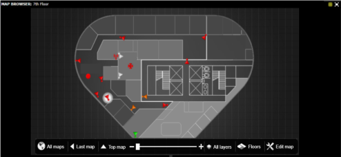
The Map Browser will display any Maps the user has permissions for and when active with a mouse will have an Overlay for changing maps and layers. The Map Browser can be controlled via a zoom with a wheel mouse (or zoom slider) and can be panned by holding down the left mouse button and dragging in any direction.
Map Integration
The Map Browser allows the user to view custom uploaded maps integrated with device objects (cameras, door objects, buildings, etc.). The maps can be designed or built using any graphical editing tool and uploaded in the Map Layout Editor as a:.bmp, .jpg, or .png file extension. Also, the user will have the ability to integrate GIS Maps from providers such as OpenStreetMaps.
Within the Map Layout Editor users can manipulate where the integrated objects will appear on the map itself.
Dynamic Device Icons
The Map Browser displays dynamic device icons that change state based on different event detection. (camera motion alert or access control door event, etc..) As an example, if you have set up motion alerts, the icon will briefly flash red indicating motion or if an access card is scanned, the door icon will briefly flash red indicating a door event. These dynamic icons provide increased situational awareness for any facility or site.
Next Topic: Map Browser Overlay


_168x52.png)

